Satellite Imagery

Simrad Unveils New Ultrawide Marine Display
Marine electronics and navigation company Simrad Yachting introduced the NSX ULTRAWIDE, said to be the world’s first fully-featured ultrawide marine display. Delivering all the benefits of dual screens in one place, the new NSX ULTRAWIDE is up to 63% wider than the NSX and provides a more streamlined and immersive experience resulting in an elevated dash aesthetic that unlocks new possibilities and a superior charting experience.“With a show-stopping aesthetic and enhanced functionality…

C-MAP: East Coast Charts Now Shipping
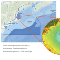
C-MAP said its C-MAP Reveal charts for the East Coast are now shipping. C-MAP Reveal cartography offers all the navigation data and capability of a C-MAP MAX-N+ card, plus ultra high-resolution bathymetric (HRB) imagery of the sea floor, including a clear view of structure, wrecks, isolated reefs and ledges in between the contour lines.The C-MAP Reveal imagery replaces shaded-relief data in select areas with more accurate depth variations, allowing it to reveal the best fishing and diving spots.
RCCNZ Praised for Missing Schooner Search Effort
The search for the missing schooner 'Nina' by the Rescue Coordination Centre New Zealand (RCCNZ) in June-July 2013 went beyond what many overseas authorities would have conducted, an independent reviewer has found. RCCNZ explain that David Baird, former General Manager of the Australian Maritime Safety Authority’s Emergency Response Division, conducted the independent review at the request of Maritime New Zealand Director Keith Manch. The reviewer found: “In many areas RCCNZ went well beyond the requirements of the SAR Convention and its Standard Operating Procedures…
NavPlay Upgrades Chart Table Routing App
NavPlay, a manufacturer of iPad apps for boaters, released the latest feature of its NavPlay navigation app, Chart Table. NavPlay’s exclusive Chart Table is designed to allow boaters to plan routes on their iPad just as they would on their boat’s chart table. A dedicated mobile environment for charting, planning and navigation, NavPlay uses the standard iPad interface making it easy for users to learn and confidently use all features of NavPlay and, in particular, Chart Table. With satellite imagery and C-Map by Jeppesen vector charts…
